Web Soil Survey
- Erin Langager

- Aug 4, 2020
- 2 min read
Updated: Aug 8, 2020

Soil is literally the foundation of all land (duh). In order to properly manage an area, successfully grow crops, or build new infrastructure we need to know what kind of condition our foundation is in to see if it's viable for what we need to do. Luckily, we have a very useful resource to help us with this information: the Web Soil Survey (https://websoilsurvey.sc.egov.usda.gov/App/HomePage.htm)
Run by the USDA, the web soil survey allows you to select an area of interest and pull all sorts of useful (and very in-depth) information about the soil of your area. As a completely new user who knows very little about soil science in general, the site can be a bit intimidating at first. Once I began exploring a little more, it became apparent that the site is very good about describing different terms and symbols you'll come across in various reports.
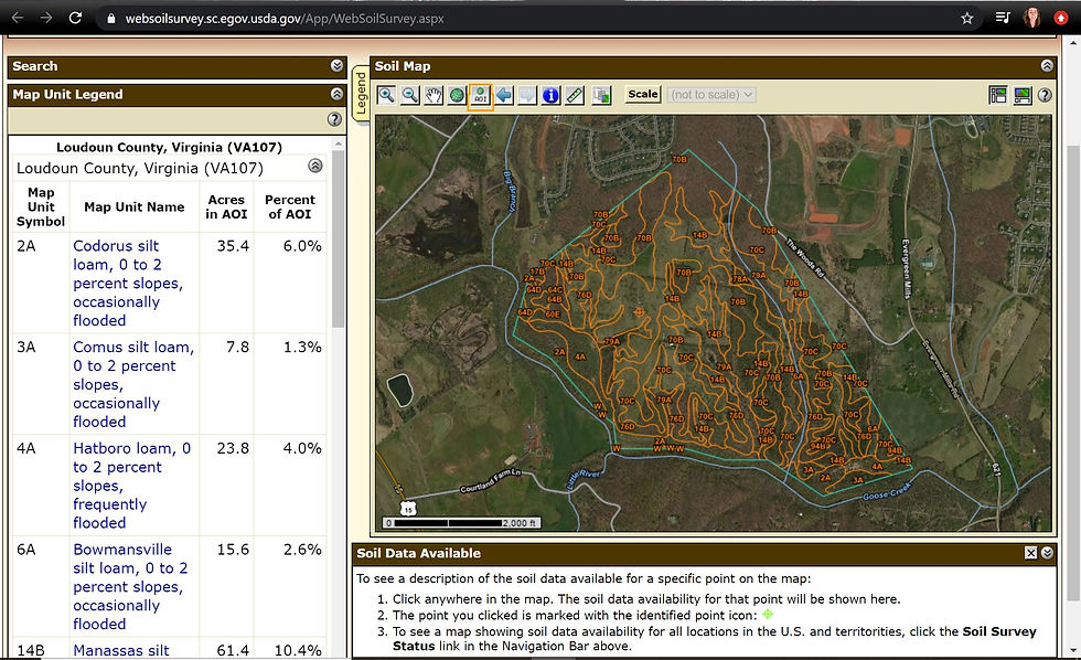
I first searched for Banshee Reeks and outlined the property to define my area of interest (AOI). This is the first screen to pop up - it breaks up your AOI by the dominant type of soil. Though I'm not entirely sure what all the different types of soils mean (Codorus silt loam vs Hatboro loam? no clue), I do know that the smaller areas are delineated whenever there is a significant change in the type of soil.

If you click on a specific Map Unit Symbol, you can see a lot more in depth information about that region of your AOI.

Using the Soil Data Explorer tab, you are able to look at different specific properties and qualities, such as drainage, chemical make up, organic makeup, and so on. Shown is a map detailing drainage. By clicking legend next to the map, I'm able to get a key to what all the different colored areas describe. It seems like Banshee Reeks mostly consists of well drained soils, with somewhat poorly drained/poorly drained soils in areas I know to be wetlands.

Along with detailed reports about soil properties and qualities, there is another tab labeled Suitabilities and Limitations for Use which allows you to explore the capability for using your AOI for various activities such as farming, construction, recreational development, land management, waste or water management, and so on.

As you explore the different reports, if you come across something that will be useful to your work you can click the Add to Shopping Cart option to download that report at the end of your session. Once completed with your search, you can go to the Shopping Cart tab to checkout and download all your selected reports.

You can also at any time Download Soil Data for whatever particular property you're looking at. I downloaded one specific to trees, which told me what kinds of trees correspond with different soil types.
While a little intimidating at first, the Web Soil Survey is an extremely useful tool to give the user any and all soil related information related to any area of interest. You can explore specific areas, like Banshee Reeks, or look at larger areas such as whole counties or states!


Comments